We had another 3 day good weather window, but I had commitments in town on Friday so could not leave until Saturday morning. Over the decades that I have lived and boated from Ketchikan I have made many trips back into the Misty Fiords area in several different boats. I even had the account of one of those trips published in the Passagemaker magazine. But it had been several years since I was back there and so I decided to head in that direction.
I pulled out of Bar Harbor at about 6:45 AM in calm and sunny conditions.
Somewhere up on that hillside above the Marine View building sits the house on 6th Ave that we moved into on Oct 1, 2021. Sadly I have had to sell it. I will surely miss the view that it afforded over this part of the harbor. I really enjoyed watching all the boats come and go in the Ketchikan harbor.
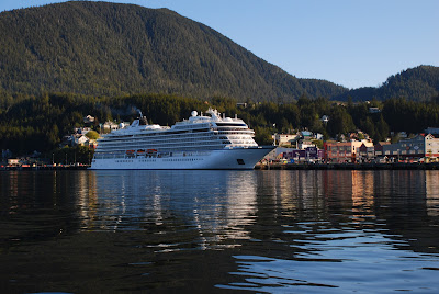
Since it was so early all the cruise ships scheduled for the day had not yet arrived, with only 1 ship in port as I passed by the downtown area. On some days we have as many as 6 ships in town at the same time carrying over 15,000 passengers and who knows how many crew.
This is the yacht Jackpot which has been here in town for a couple of years. It is 164' long with an estimated cost of $35 million. I had the unique opportunity a few months ago to go out to the boat, but really did not get to see very much of it while I was there. I can see this boat from the dining room of the 6th Ave house.
This is the USCG base in Ketchikan. They have several different classes of ships that are based here. I did not know it when I passed by but I would see one of them a little later in my trip.
This is Doyon's Landing. They may offer other services that I am not aware of, but I do know that they offer transient moorage to yachts that come through town which are too large to fit into any of our harbors. These large yachts can and sometimes do anchor up in front of Pennock Island near the Jackpot. But that is not quite as convenient for them as they have to use their tenders to go back and forth to town.
About 11 AM the USCG Cutter John McCormick came up behind me and passed me going about 24 knots. I usually cruise between 8 and 9 knots, to give you some comparison. A big ship going very fast, creating a huge wake. I’d like to know what his GPH fuel burn is.
My navigational system has an AIS receiver. AIS is Automatic Identification System. My boat receives only and does not transmit. Larger boats are required to both transmit and receive. The AIS signal contains a lot of information about the vessel; its name, size, speed, direction, hailing port, MMSI number, etc. That’s how I knew how fast the USCG Cutter was going.
My Garmin GPS unit receives these signals and shows the
vessels in either green or red markers on the screen. If the unit determines that the approaching
vessel may be on a collision course within a few miles, then it turns the
marker red and sounds an alarm which must be responded to. When you are out at sea this is a good thing
because it alerts you to vessels in your area that may be of concern. However, when leaving or entering a harbor
there are numerous vessels transmitting and most of them are stationary. So, the alarm sounds repeatedly, and you have
to respond to each one, or cancel the alarm entirely.
Whenever you see a USCG vessel approaching you always have to be aware that they may stop and board you for a safety inspection. A safety inspection checks for life jackets, fire extinguishers, flares, vessel documentation, placards regarding discharge of oil and trash, etc. If you get a good report you don't have to undergo another safety inspection for a calendar year. On this day they just flew past me and did not even slow down.
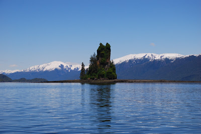
One of my goals for this trip was to see New Eddystone Rock again. It is one of the "must sees" in this area. If you want to read more about it you can see the Wikipedia link at New Eddystone Rock - Wikipedia
Basically it is a 237' volcanic plug that sits atop the Eddystone volcano, most of which is underwater. It is a very impressive sight and one that tourists come from all over the world to see.
This first photo is from about 10 miles away, and it is that small black island in the very center of the photo.
Just like photos of my boat, one can not have too many photos of New Eddystone Rock. The seas were flat calm, and the sky was sunny, so I drifted there for awhile and took a lot of photos (with my messed up camera.)
Several years ago a friend of mine was back in the area with some out of state guests and he wanted to show them the rock. He had a metal boat with a jet drive (no props) so he just drove it up onto the gravel beach and they unloaded. He walked his anchor up the beach and dug it down into the sand and gravel. They walked around the base of the rock. As he started back to the boat he saw that the wind had come up and his anchor was dragging. He ran for it but eventually ended up in the water swimming to grab the anchor line. He got ahold of the line, and pulled himself up to the boat, but most boats are not set up to allow people to get aboard from the water. He somehow managed to get aboard, but he told me he almost bought the farm that day. It was mid May and it was still very cold out. It's easy to get into trouble in a hurry in this country so one has to be alert and aware at all times.
I had intended to spend the night on a mooring buoy in front of a USFS cabin on Winstanley Island, just a mile or two from New Eddystone Rock. However, in this country one must always have a Plan B and a Plan C. The access to Winstanley Island requires going through Shoalwater Pass, which has a very shallow bar to be crossed. It was just now low tide so I had to wait an hour or so before there would be enough water to get in there.
While I was drifting and waiting I noticed a couple of small boats go into Shoalwater Pass, and so I presumed that they had gotten the one mooring buoy that is in there. I can anchor in there, and have done so many times, but it's harder to anchor when alone, so I preferred not to have to do that.
Plan B was another mooring buoy in front of Ella Creek, just a couple miles on the other side of Behm Canal. I putted on over there and got tied up to the buoy with no problems. The little cove is exposed from the north, but the weather forecast was good so I expected no problems spending the night here.
While glassing the beach with binoculars I noticed a "cairn" (A cairn is a man-made pile (or stack) of stones raised for a purpose, usually as a marker or as a burial mound) with water bubbling up out of the top. And a few feet away more water was gurgling up out of the beach rocks.
My camera doesn't do it justice. I have been here before but never noticed this. Even at high tide, when the cairn was underwater, I could still see the water bubbling up as if from an underground spring.
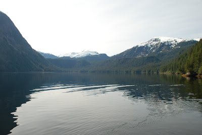
Here are a few additional shots from my spot for the night.
It wasn't in my original plan, but I realized how close I was to Punchbowl Cove and how unlikely it was that I would be back in these waters anytime soon, so I decided to go on over there and get some photos. Punchbowl Cove is one of the most impressive areas in all of Misty Fiords. The sheer rock walls were apparently just carved by the ice, creating what appears to be a large punchbowl. There is a mooring buoy at the back of the cove, but only the one. There is a trail that goes steeply up to Punchbowl Lake that I have trekked in my younger days.
I just went into the cove and shot as many photos as my disabled camera would allow.
Now it was time to beat feet for home. My original plan had been to plan my arrival into Bar Harbor at about 8 or 8:30 PM, but I ended up just going in earlier than that. The weather here in Misty Fiords did not even resemble the weather that I experienced as I got closer to town.
As I approached Pt Alava to turn the corner towards home I saw a marker pop up on my AIS. Oddly it did not show a vessel name, only showing "Unknown Vessel." I had never seen cruise ships in the Misty Fiords area but this vessel looked to be a small cruise ship about 300 - 400' long. As I got closer I could see the name, "Roald Amundsen."
The rest of the trip was uneventful, except to say that the closer I got to town the worse the weather got. There is a short stretch between Mt Point and Saxman where you are exposed on the port side to seas coming in from Nichols Passage. I got rocked around pretty good in that section until I got inside the protection of Pennock Island.
I stopped for fuel, and you don't want to hear about that, with fuel prices the way they are now. Suffice it to say it is scary.
I got into the stall about 4:30 PM, in a stiff breeze, which always makes it harder when you are alone.
Total mileage for this trip was 103 nm.
Now it's time to plan my next adventure!


No comments:
Post a Comment