Wednesday, May 16, 2018

2018-05-02 Ketchikan to Gig Harbor - Part #1

As anyone who has been reading my blog knows, my wife and I recently made the decision to move to Gig Harbor WA.  A significant part of that process was to run the boat down there at some point.
Well, that point in time had arrived.

My daughter Karen was slated to be my crew for this trip.  Karen is in the Army, stationed in Wisconsin, but she had secured enough leave time to come up and help me with this trip.


My longtime friend Bob Hammer came by to say goodbye the night before we left, and he was nice enough to shoot this photo of Karen and me before our epic voyage.

The first leg of our journey was from our home slip in Bar Harbor to Foggy Bay, which is just a little over 32 miles.


This map snippet shows the route to Foggy Bay.  Most of it is protected but it can be rough in places.  My weather guru gave us the green light for the run so we pulled out around noon.

The run up to Foggy Bay was bouncy and uncomfortable, but not dangerous.  The autopilot failed multiple times, which was really disappointing since it is brand new.  (See my prior posting for the Petersburg/Wrangell trip.)

Captain Karen at the helm


This is our "mound" of food, gear, spare parts, and miscellaneous stuff on the flybridge seats.
Thank heavens for this area to store stuff, because I don't know where it would go if we couldn't put it there.

We got into Foggy Bay about 4:30 PM and secured for our first night out there.
It was rainy, and cool.

The second leg of this trip is from Foggy Bay to Prince Rupert.  This requires crossing Dixon Entrance, which is one of the two primary open ocean crossings required in order to get from Ketchikan down to the Seattle area.

My weather guru said the next day would be calm seas, and so Karen and I pulled out of Foggy Bay at about 5 AM, just as it was getting light.


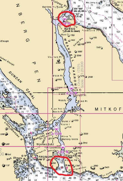
This map snippet shows the route from Foggy Bay to Prince Rupert.
This is an old screen shot which shows us going south of Digby Island and then north back up to Prince Rupert.
In fact we went through Venn Passage, which is a short cut to Prince Rupert as you approach from the north.  It is shallow and somewhat dangerous in there, but I had gone through there before and felt confident that we could make it, and we did.
Going through Venn Passage saves going several miles out of your way just when you are the most tired.


The blue line shows the out of the way route, and the red marker shows the route through Venn Passage.

Water conditions on the route were excellent and we had no issues, other than the fact that the autopilot kept failing.

When we got into Prince Rupert we had to deal with Canadian Customs.
I had what is called a CANPASS, which is a pre-screened, expedited customs clearing process.
Karen did not have a CANPASS, and so we were instructed to go to our marina, Cow Bay Marina, and call them from there, which we did.
They asked several questions and then issued us our "Reporting number."
This number is critical to have on hand while transiting Canadian waters, in case we are ever challenged along the way.

There is also a one hour time change (+1) when arriving into Canadian waters, so we had to reset clocks and watches for that.

Cow Bay Marina was great. 
In the past I have always stayed at the Prince Rupert Rowing and Yacht Club, which is right next door, but a friend had recommended this marina, so we stayed there.
They were super helpful, super friendly, and the slips were large and easy to access.
Shore power was clean, and easy to access.
Washrooms and showers and laundry were easy and cheap.

From Cow Bay Marina it is an easy walk up to the shops and stores of Prince Rupert.
We went to Safeway, Walmart, and a few other places.
I had brought my rolling cart.  It is light, easy to drag, as it has big bicycle tires, and easy to fold up and stow when done.  It sure makes hauling groceries and provisions a lot easier.

We did some laundry at Cow Bay Marina as well, just because it was close, convenient, and cheap.
Of course we had to get a supply of "Loonies" for the machines, which we got from the harbor guy.

I had gotten some Canadian currency (in bills) from First Bank before departing on this trip.
They don't carry it on hand, so you have to order it and then wait a week or so for it to come in.

As I mentioned in the previous post I have been having trouble with my Nikon D80 camera, which I've had for many years.  So right before this trip I bought a cheaper camera from Walmart, just so I would at least have one good working camera.  My Nikon seems to work OK with my telephoto lens on it, but not with the regular lens.

Here are some photos we took during our 2 night stay at Cow Bay Marina.  I should mention that Karen took the best seal shots, but I think I took the best shots of other boats.


Faraway at her slip at Cow Bay Marina.
Why is it the other boats in the area always seem bigger and nicer than mine?
The boat on our starboard side was named "Runaway," so we had Faraway next to Runaway.

This is a tourist boat called the Inside Passage

A beautiful Nordhavn - "Ammonite"


Karen says he looks "angry" in this shot.

When I did an engine room check after arriving in Prince Rupert I saw significant leakage of hydraulic steering fluid around the steering pump and the steering ram.

I called a machine shop that specialized in marine hydraulics and had someone come down and work on the autopilot.  They did not really change anything on the autopilot itself, but they did reseat some hydraulic hoses on the pump and on the steering ram.  Since they have done their work the autopilot has not failed and there has been no leakage of steering fluid - Yay!

We stayed 2 nights at the Cow Bay Marina, mostly because we had to wait for the mechanic to come down and work on the steering fluid leakage.  But it was definitely worth the wait.

The next 2 nights were slated to be remote anchor sites, i.e. not in a marina.

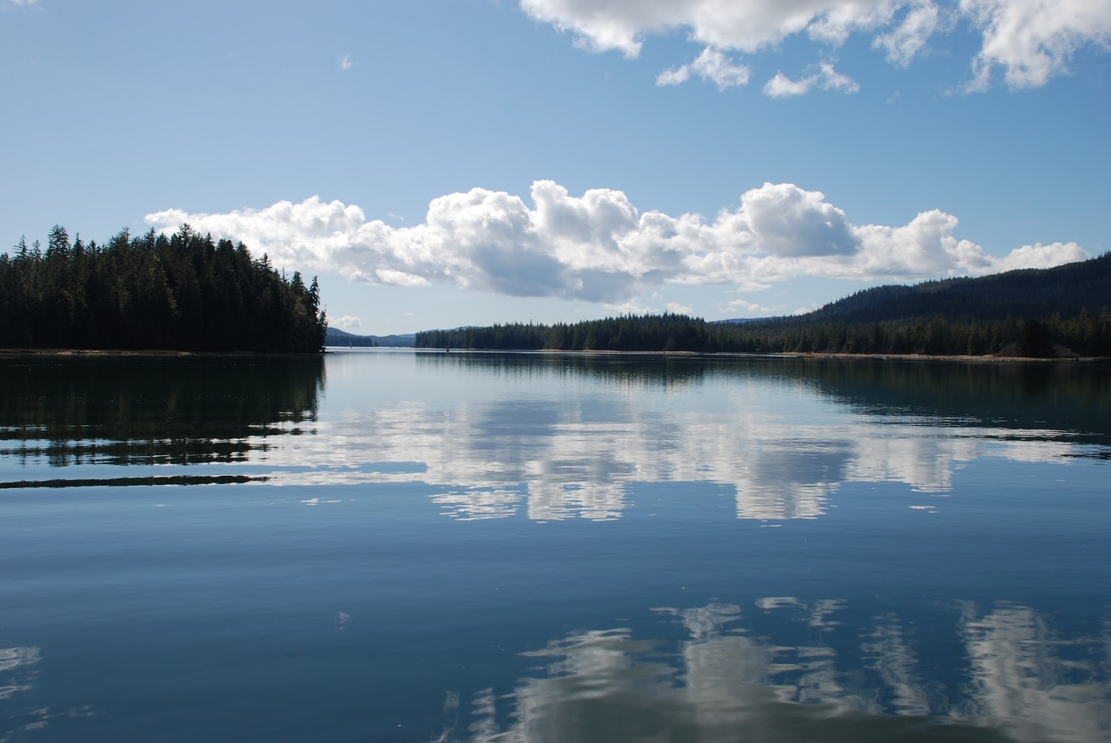
The first of those 2 nights was in Lowe Inlet, a place I have anchored a few times before.


Here is a map snippet that shows the route from Prince Rupert down to Lowe Inlet, which is in Grenville Channel.  I think it is about 50 miles down there.

When we got there 2 other boats were already at anchor (photos to follow).  I chose an anchor site and dropped the anchor.  When we were finally set I saw we were only in about 30' of water, so I was not happy with that set.  So we pulled the anchor, our first anchor set and pull on this trip.

When the anchor got up near the surface we started to have all kinds of trouble with it, and I could not figure out what was going on.  I had Karen up on the foredeck with me to help.

When the anchor finally came into view I saw the problem -  it had snagged a small rope, which was under a lot of tension.  I have no idea where this rope was attached or how it came to have so much tension on it, but we had a devil of a time getting it off the anchor.

Eventually I got it off with a boat hook and we reset the anchor in a little deeper water, and we were set for the night.  Conditions were dead calm and beautiful.

Some photos of the area and of our neighbors for the night.


The next day we were up early and pulled the anchor with no issues this time.

Our goal for this day was a beautiful little nook called Bottleneck Inlet, where I have anchored several times before.  Distance from Lowe Inlet to Bottleneck Inlet was about 73 miles, a fairly long day for us.

Here is a map snippet that shows the route for the day.


Lowe Inlet is up there in the upper left, and Bottleneck Inlet is down in the lower right.
The route for the day is in blue.

It was a fairly protected run, but we did have some unfavorable conditions when we crossed wright Sound, that open area just before entering the protection of Princess Royal Channel.  The seas were large and they were coming at us from the port beam, trying to push us a direction we did not want to go.  That is one of the hardest situations to deal with on a small boat.  If we were heading straight into these seas they would not have been such a problem.  As it was they kept pushing us off course and we almost broached (rolled over) a couple of times.  Fortunately the crossing was short, so we made it OK.

We passed a couple of stunning waterfalls along our route - the photos don't really do them justice.


At about 4:30 PM we anchored safely in Bottleneck Inlet.  No one else was there when we came in, and no one else came while we were there, which was not surprising to me.

It is a beautiful area.  Here are some shots from Bottleneck Inlet.


We had a great dinner and a quiet night on the anchor here in Bottleneck Inlet.

Our next destination was to be Shearwater Marina and Resort.
It was about 50 miles away, and in order to get there we had to go through Jackson Narrows and also Reid Passage.
Jackson Narrows was not dangerous, but it was "skinny" in places.
Reid Passage is very skinny and you have to announce on the radio your intention to enter it so that you don't encounter a vessel coming the other way.  In most places there is not room for two boats to pass each other.
Taking Reid Passage allows a vessel to skip most of Milbanke Sound, which can be a dangerous open water crossing.

Here is the route, with Bottleneck Inlet at the top and Shearwater at the bottom.


We made our way down with no issues in either Jackson Narrows or Reid Passage.
When you come out of Reid Passage, southbound as we were, you are dumped out into Seaforth Channel, which can be rough is Milbanke Sound is rough that day.
We were lucky and found Seaforth Channel to be very calm for us.

Along the way we picked up a hitchhiker for a short time.
In all the years I've been boating I don't recall this ever happening before.


We arrived into Shearwater area about 2 PM and took on 550 liters of fuel there.
Don't ask what it cost!

We got tied up to their dock, got hooked into shore power, figured out how to get on their WiFi, and we were set for awhile.

We ended up staying here 3 nights.
We had intended to stay 2 nights, but we stayed the third night on the advice of our weather router, who advised us to hold there for better weather in Queen Charlotte Sound.  More on that later.

Here are some photos taken during our stay at Shearwater.


They have a new sign that wasn't here the last time I came through.


Karen stands by Faraway at our spot at the dock.
We were right near the power distribution block so that was nice.

They have made one improvement here that I really appreciate.
In the past they had one fresh water hose that ran the full length of the long dock.
In order to fill fresh water you had to follow that hose and figure out who was using it, and then ask them if they would let you know when they were done.  Oftentimes they would say sure, but some other boat (or boats) are ahead of you.
Now they still have only one main water line (that big yellow hose running along the bull rail) but they have added "T" connections every 50' or so which allows many boats to fill fresh water at the same time.


In the two photos above you can see the difference in the seasons.
The upper photo was taken on this trip, May 2018.
The lower photo, of the same building (from a slightly different angle) was taken in late August of 2015.
They do a lot of charter fishing out of Shearwater, and they had not yet put their fishing boats in the water for the season when we were there on this trip.


There are several buildings in this facility.
This one houses a laundry & shower room on the far left, and some small shops to the right.
I don't know what is on the upper floor, but I suspect they are apartments for some of the workers.


This is their fuel dock.
I am told it is one of the few places in the area where helicopters can refuel, so during the day there are frequently helicopters coming and going.


This is just an oddity.
On the back doors to our main cabin there is lettering that reads "Mainship Trawlers."
The sun was so bright that the lettering transferred almost perfectly inside on that panel.

We had a little bit of drama and a very close call on the dock one afternoon.
A boat about the size of ours was pulling away from the dock to leave and one of the men from the boat was attempting to push it off from the dock and then climb on board as it swung away.
He was an older gentleman, who walked with a cane, so he was not exactly agile.
He pushed the boat out but when he attempted to swing himself on board he did not make it over the rail.
So when we saw him he was hanging off the side of the boat desperately trying to pull himself up.
Just as we headed out of our cabin to try to assist he managed to literally claw himself over the railing.
A close one for sure.

We were anxious to get underway but our next nautical challenge was to cross Queen Charlotte Sound (QCS).  Our weather expert recommended holding at Shearwater at least another day.

So I will close out this segment of the blog, but pick it up with Part #2 as we depart from Shearwater.


Tuesday, April 24, 2018

2018-04-22 Petersburg-Wrangell Trip

As I noted in my last post I had plans to take the boat to Petersburg and Wrangell in order to get some work done, and this is the posting that covers that trip.

I regret and apologize that I did not take more photos, but here are my excuses.

Excuse #1: Part of the trip was done quite quickly, in order to get up to Petersburg as fast as possible, so photos were not really on my mind.

Excuse #2: A good portion of the trip, in fact the entire southbound portion, I did solo, so taking photos was difficult.

Excuse #3: I am having trouble with my camera.  It doesn't want to focus.  So I had to throw out some of the few photos that I did take.  And a couple that I include here are a little blurry because of this.  I need to get to the bottom of this before I head to Gig Harbor.

So here is the timeline I was working with.
Alaska Commercial Electronics in Petersburg was scheduled to start working on the autopilot installation on Friday April 13.  It is about 120 miles from Ketchikan to Petersburg, so at the very least it is a 2 day trip.  So that meant I had to try very hard to be there by Thursday April 12th.

Wrangell Boat Shop was scheduled to haul the boat out in the afternoon on Wednesday April 18th.  It's only about a 5 or 6 hour run from Petersburg down to Wrangell, so that meant I had to leave Petersburg by the morning of April 18th at the very latest.

I had hoped to leave Ketchikan on Monday April 9th, with my long time friend and former co-worker John Clifton as crew.  John and I have made many trips together on various boats, but I don't think he has ever come with me on Faraway.

John had commitments in Seattle and arrived back into town on Monday evening about 5 PM, really too late for us to leave that day.

On Tuesday April 10th one of the biggest storms we have had hit Ketchikan, with winds of over 70 knots.  Sometimes it is hard to make that go/no go decision, but it was easy that day.

So we left on Wednesday April 11th, about 10:30 AM.

I did not get a picture of John from this trip, so I pulled this one from my archives.


This was from a trip we made in February of 2011, hence the warm clothing.

Wrangell is about 85 miles north from Ketchikan, and the first part of the trip is in Clarence Strait, which can be very rough.  But we had a good forecast for that day and we were fortunate to have a nice smooth run up Clarence Strait and into Ernest Sound.


This map snippet shows the route from Bar Harbor to Meyers Chuck, about 32 miles, most of it pretty exposed in Clarence Strait.  Maps are deceptive, and they make it look like you can go anywhere at anytime.  Not so.  This is big water and it can be very dangerous.


This map snippet shows the route from Meyers Chuck up through Ernest Sound and then Zimovia Strait to Wrangell.  After you turn that corner at Meyers Chuck and get part way up into Ernest Sound it is mostly protected waters.  It may be windy, but there probably won't be big seas to deal with.

I had a route already built into my Garmin navigational unit and it provides a wealth of information on the trip, including estimated arrival time.

I bumped the speed up a little bit and that brought our estimated arrival time into Wrangell at just about 7:30 PM, right before dark.

We arrived right on time and got hold of the Wrangell Harbor Master by VHF radio in order to get transient moorage and shore power at Heritage Harbor.

We had a late dinner of spaghetti and salad after which we were both ready for bed.

It was a quiet night in the harbor, and in the morning we pulled out about 6 AM destined for Petersburg.

In order to get up to Petersburg you have to transit the Wrangell Narrows.  I have made that transit many times, but it is always a bit of a challenge to get through there.  It is very shallow and very narrow in places, and the tides and currents are significant.  On this trip we hit the currents just right and had a very helpful push as we made our way up through the Narrows.


This map snippet shows the route from Wrangell (on the right) over to the southern entrance to Wrangell Narrows (left side).  It's a little over 20 miles.


This map snippet shows the Wrangell Narrows, with the southern entrance circled in red at the bottom, and Petersburg circled in red at the top.  I do not have a formal route charted through the Narrows themselves because there really is only one route - you follow the navigational markers.  It's about another 20 miles up through the Narrows to Petersburg.

At the base of the Narrows we saw the USCG Cutter Bailey Barco (sp?) anchored, and we saw their large red inflatable go racing past us at one point.  They just waved as they went by.

We worked our way up through the Narrows and were just about to pull into the fuel dock in Petersburg when we were hailed on the VHF radio by the inflatable from the Bailey Barco that they were going to come aboard and do a safety check.  They don't ask, they tell - they have guns.

A safety check is where they check for things like life jackets, flares, fire extinguishers, paper work, etc.

We pulled into the fuel dock and they did the inspections there.

They also had on board a Federal Fisheries officer, who was interested in whether we had been fishing and whether we had any fish on board.  I told him we had not been fishing but that I had some frozen fish in my freezer that I had brought from home.

He took exception to the frozen halibut and said it was a violation to have frozen fish on board that was in such a condition that they could not tell how many had been caught.  He said he would not fine me (Thanks!) but he would send me a formal letter of violation.

I passed the USCG safety inspection with no violations, and we took on some fuel, and made our way into a slip.  By now it was about noon.

We were in North Harbor, just at the base of the ramp

Petersburg has 3 harbors: North Harbor, Middle Harbor, and South Harbor.  My contact at Alaska Commercial Electronics, the company installing the autopilot, had asked me to get into North Harbor so that it was close to their shop.  Just by chance he was in the harbormaster's office when we pulled in so that helped us get a good slip right near the base of the ramp.


Petersburg Harbors


This interesting barge with a truck cab on top was here when we came through last summer.
I think it is the base from which a welding shop works.
You can't tell from this photo but there was a big metal barge on the inside of the Pegasus, and they would fire up a welder or a metal cutter from time to time and work on the barge.


Faraway at her slip in North Harbor

John and I shared a last lunch and he left for a flight back to Ketchikan at just about the same time the guys from Alaska Commercial Electronics came down to start work on the autopilot.

For those that don't know, an autopilot on a boat is an electronic device that allows the operator to set in a compass course, and the autopilot will then steer the boat on its own.  It can do many other things if it is integrated into a navigational unit, but my installation was just to install the autopilot.

When a boat is being steered by an autopilot the operator still has the responsibility to be at the helm and watch over the progress of the boat.  By maritime law a boat is required to have someone at the helm at all times, even at anchor, when the boat is not tied to a dock.

They worked on the autopilot most of Thursday afternoon, and all of Friday.


This is the lower helm station, opened up so they could get to the hoses and wiring underneath it.
On this boat the lower helm station is an option, and the upper helm station on the flybridge is standard.


This is the DC (Direct Current) distribution panel opened up so they could add a new breaker for the autopilot.

One of the components of the autopilot system is a hydraulic pump, which is installed down in the engine room, in the stern, near the rudders.  Even though the pump they installed was brand new it was defective.  So that delayed us a bit while they scoured SE Alaska trying to find a replacement pump.

They finally found one in Juneau and one of the guys came back on Saturday afternoon and installed it.  Then we took the boat out for a short sea trial so that we could confirm that it worked, and he could show me how to use it.


That black unit in the middle is the control unit for the new Furuno autopilot at the lower helm station.


An identical control unit was installed to the left of the gauges on the flybridge helm station.

These control units are just part of the system.  There is a processor and an electronic compass mounted down below out of view, and the hydraulic pump and a rudder angle sensor are also mounted below, out of view.


That gold colored thing on the right is the "steering ram" that actually moves the rudders.
The black pump is in the middle, and it receives signals from the processor that tells it whether the boat needs right rudder or left rudder in order to achieve or stay on the desired compass setting.
The smaller black unit on the left is the rudder angle sensor.  It just moves along with the rudders and tells the processor the angle that the rudders are on, such as 10 degrees to port, or 15 degrees to starboard.

The processor and the compass are tucked into a little shaft where it was basically impossible to get good photos of them.

At some point I will probably connect the autopilot to my Garmin GPS navigational unit and then the autopilot will have much more of its functionality unlocked and available to me.

With the autopilot installation finished there was no need to stay in Petersburg, so the next morning, Sunday, I made my way south through the Wrangell Narrows to Wrangell.  I waited until the tides and currents in the Narrows were favorable and timed it just right to catch a boost all the way down through the Narrows.  I have made that trip before when the currents were not favorable and it is very discouraging.  You are burning lots of fuel but barely making any progress.  It's well worth waiting for the favorable currents.


The ride down was beautiful.  I just had to stop at one point and take some photos.  I should point out that the ripples showing in the photo up above were from my boat wake when I stopped.  It was really just glassy calm and serenely beautiful.

I did not use the autopilot much in the Narrows because there are a lot of turns and it is a winding route.  But once you pop out of the Narrows on the southern end you still have about 20 miles or so to get to Wrangell.  I did use the autopilot there.  It did not have to work very hard because the seas were very calm.

At one point it crashed, for lack of a better word, with a "Rudder Drive Error."  I looked it up in the manual and it said to shut down the system and restart it, which I did.  It worked OK after that.  The guys in Petersburg said there was probably some remaining air in the new hydraulic hoses that needed to be bled out.

I made it down to Wrangell and got tied up in exactly the same spot at Heritage Harbor that John and I had been on the north bound leg of this trip.

I was not scheduled to be hauled by the Wrangell Boat Shop until Wednesday afternoon and I had arrived on Sunday evening.  On Monday morning I checked in with them to see if they could take me in early, but no such luck, they were tightly scheduled.  So I just had to hang out and wait until Wednesday afternoon.


These 2 eagles were standing guard at the entrance to the harbor for most of the time that I was there.


There is a fish processing plant of some sort right inside the entrance to the harbor.  I don't know its name.  From time to time commercial boats would pull up in front and unload fish, looked like mostly halibut to me.  The crane operator uses that yellow crane to drop a bin of sorts down into the hold.  Then crewmen fill it up with fish, and then it is hoisted back up.  Every once in awhile I would see a big halibut come up that was just tied to the end of the hoist, because it was too big to fit into the bin.


Some of my neighbors at Heritage Harbor.

That huge vessel the Bulldog was there when we came through last summer.  Here is a photo from that trip.


You can see that it has been painted bright blue since we were here last.  The vessel appears to be owned by Trident Seafoods, and is probably used as a fish packer.  Fish packers go out to the fishing grounds and the commercial boats can sell their fish directly to the packer without having to run all the way to town.

On Wednesday afternoon, right on schedule, the Wrangell Boat Shop guys hauled Faraway out of the water.  They use a cradle sitting on rail tracks, and then a big winch pulls the cradle with the boat in it up inside a covered area.


I had never been on board when they hauled it out on a cradle like this, so it was a new experience for me.  I wasn't there last year when they did it.  They had a couple of young people from the WBS on board, one on each side, to help guide things along.  We were all waiting for something to happen when Allie, the WBS employee on the starboard side, opened the door near the lower helm and informed me that there was a "slight problem with the winch," and that Pat, the owner had to drive over to the store and get some bolts.  Knowing that the winch that is supposed to haul my 10+ ton boat out of the water needs some new bolts did not exactly boost my confidence at that moment.


My plan this year was to stay/sleep on the boat while it was out of the water.  Last year when I did this maintenance session I took the ferry back to Ketchikan, and then flew back when the boat was ready.

Since the boat was high and dry I could not use the toilet on board.  It draws in salt water for flushing, but of course that doesn't work when it is out of the water.  But not to worry, the WBS staff provided my access to their shop rest room, and I was grateful for it.


The boat sat at a slight stern down angle on the cradle which made moving around inside a little weird.  It also creaked and groaned when I moved from side to side, so it made me wonder if they had ever had one slide off the cradle.  I didn't ask - not sure I really wanted to know.

In any case they did some necessary spring maintenance tasks -

     pressure wash the bottom
     paint the bottom
     replace all the exterior zincs
     replace all the pencil zincs on the engines
     replace the elements in the Racor fuel filters
     replace the glow plug in the diesel furnace
     check all belts, all good
     replace raw water impellers in the main engines
     replace the O rings in the seas strainers for the main engines
     replace the O ring in the sea strainer for the generator
     check the thru-hull fittings for the sea water cooling system, all good
     diagnose and repair a freshwater leak from the hot water heater
     replace all wiper blades
     bleed the air out of the hydraulic steering system

Boats need continual maintenance or things just start breaking down.
Some of the above tasks I used to do myself, but as I have gotten older it is much harder for me to crawl around that engine room like I used to.  I don't bend as easily as I once did.  So some of these tasks are actually impossible for me to do now because I cannot contort my body into the required position to perform them.

I will be taking the boat about 900 miles from Ketchikan down to Gig Harbor beginning around the first week of May and I wanted as much preventive maintenance done as possible.  I want to do as much as I possibly can to insure an enjoyable and break down free voyage.  Time will tell how well I did on that score.

The Wrangell Boat Shop guys were done with the boat, or so we thought, by Friday afternoon.  Their facility is in what is called the "Inner Harbor" in Wrangell, and boats can only be hauled or launched at high tide.  So they launched me about 4:30 PM on Friday, in a driving cold rain.


The red star approximates where the WBS is located.  Very shallow back there.

When I first got back in the water I had one of the guys from the yard get down in the engine room when I started the engines to insure that there were no leaks - there were none.  Since they had replaced an O-ring on the generator I also wanted to start the generator to insure no leaks, but the generator would not even begin to turn over.

I moved the boat over to my same old spot at Heritage Harbor and a guy from the boat yard came over in the morning and fixed the generator problem.  When they had removed the DC distribution panel a wire had slipped off its connection.  Easily fixed.

On Saturday morning at about 10:30 AM I pulled out of Heritage Harbor and headed south towards Ketchikan.  Neither my wife nor I really wanted for me to do this leg of the trip alone, but we just couldn't come up with any viable plan to get me some help.  I have had some issues with vertigo attacks in the past and they can be quite disabling.

The weather and sea conditions were great to start out.  The big question would be what is it like in Clarence Strait, the last 32 miles of the trip?

I used the autopilot for about 80% of the steering on the way home and it never crashed again.

Meyers Chuck is a little community right at the "corner" where you turn into Clarence Strait.  It is really your last chance for refuge.  Once you commit and continue on past Meyers Chuck there is no place to hide from bad weather.  Once you've gone more than 5 miles or so you really can't turn back if it's real bad either.  So that is a big decision point.

I had listened to the marine weather on the radio, and of course I could see what I could see with my own eyes when I got to Meyers Chuck.  The forecast was reasonable, 15 knots with seas to 3', and the water looked fine as far as I could see, so I went for it.  The forecast for Sunday and Monday was miserable and I didn't want to be stuck in Meyers Chuck for several days waiting for good weather.

It is about 32 miles from Meyers Chuck to Bar Harbor, and about the first 10 miles were fine.  After that it started to get bad, and continued to get worse as each mile went by.  I could no longer use the autopilot due to sea conditions, and I could not go down below and prepare the cabin for rough water.
It was not the worst 22 miles I've ever done, but I would say it was about a 7 on a scale of 1 to 10, with 10 being the worst.

I had a 1 gallon unopened can of bottom paint sitting on the starboard bench seat, and it came flying off with a thud as it hit the flybridge deck.  Thank goodness it didn't pop open - that would have been a mess!

In any case, I battered through it and was fully inside Vallenor Point before it calmed down enough for me to go below and check the damage.  It looked like a bomb had gone off in the cabin, which was what I expected.

I pulled into my home slip in Bar Harbor at about 8 PM, just as it was getting dark, in very calm conditions.   I was very glad to be "home."

As I write this on Monday evening I can say that I would have never made it in on Sunday or Monday as it is still blowing hard out there.

The next big trip will be to Gig Harbor WA.


Wednesday, January 24, 2018

2018-01-24 Update

Not much happening this winter, at least as far as the boat is concerned.
I have been sleeping down there from time to time, and I did take it out to get fuel in mid January.
Faraway needs a real thorough cleaning!

Here are the plans for spring and summer.

I've made arrangements with Alaska Commercial Electronics in Petersburg to install a Furuno autopilot.  The plan is for them to begin the work on April 13th.  So that means I need to plan to take off from Ketchikan at least 3 days prior to that, in order to get up there by the afternoon of the 12th.

They say it will take a couple of days to do the work, and to do some sea trials to make sure it is working and to train me on how to use it.

I have a maintenance session scheduled at the Wrangell Boat Shop starting on April 18th.  They say they need a week to do the tasks that I have outlined, but I suspect it won't take them that long, unless they intentionally dilly-dally.  The list of tasks is much shorter than last year's and they finished in less than a week last year.

So the plan is for me to stay on the boat in Wrangell as it is up on the "ways."  They say it is OK to do that.  Of course I will need to use the rest room in the shop, and possibly take showers at the pool.  But that is fine, and it is a lot cheaper than coming home and going back up there again.

After the Wrangell Boat Shop maintenance I will run back down to Ketchikan, hopefully in time to meet my daughter Karen, who is tentatively scheduled to fly in on April 30th in order to help me run the boat down to her new home at Gig Harbor Marina, in Gig Harbor Washington.  Wife Lisa is no longer able to make that trip due to health issues.  I am looking forward to spending some quality time with Karen on that trip.

Hopefully we will make it to Gig Harbor in a couple of weeks.

After that I plan to do some cruising in the Seattle area and the San Juan Islands area.

So that's the plan, but we'll see how reality stacks up.