I was undecided about going on this trip because the marine weather forecast was good, but not great. I guess I got a little spoiled by the Memorial Day weekend weather. It was sunny and warm, with calm winds to boot. You don't get that very often around here.
I thought about leaving on Saturday but in the end decided not to go. Then I sat on the boat all day wishing I had gone.
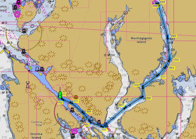
This map snippet shows the route from town up into Carroll Inlet to Shelter Cove, the farthest point on the route. Shoal Cove is on the right about 5 miles south of Shelter Cove.
Today, Sunday, I pulled out of Bar Harbor at about 7:15 AM in overcast but calm conditions. Light rain was falling from time to time.
As I slowly motored through town, I saw 3 cruise ships in port so far. I think others were due in later in the morning. Two of the ships were already tied up while the third one was maneuvering into the dock. The cruise ships are required to have a certified local pilot on board when coming into or leaving a port, and I think they are the ones that actually take it up to the dock.
In the "old days," when cruise ships first started coming to town, the ships required tugboat assistance to get in and out of the dock. But now the ships all have very powerful bow and stern thrusters, so they can move sideways, and no tugboats are required.
One of them looked like it has some kind of curly-Q water slide on the top. Looks fun.
Contrast these with the vessels on the other side, on Pennock Island.
As usual, Doyon's Landing had a couple of beautiful yachts tied up. I always wondered how it feels to dock your 80' yacht, and then have someone dock their 120' yacht right in front of you.
When I left Bar Harbor I really had not yet decided where exactly I wanted to go. This is uncommon for me as I am usually an obsessive planner. I decided to head for Carroll Inlet and figure out where to spend the night once I got there.
I checked out a couple of places, but in the end decided to head for the Shoal Cove USFS dock. In typical Federal government fashion, the Shoal Cove dock is not actually in Shoal Cove, it is a few miles north of Shoal Cove. Shoal Cove itself is very shallow and only small skiffs can go in there.
The Coast Guard used to maintain a LORAN station near Shoal Cove and this dock and the smaller one nearby were used to transfer men and equipment destined for the Shoal Cove LORAN station.
LORAN stands for Long Range Navigation, and for a long time it was the best navigational aid available for ships at sea. Now however, GPS (Global Positioning System) uses satellites to aid ships in navigation so the LORAN station has been shut down.
After getting tied up I walked up the logging road to seek good photos or videos. The USFS has a pretty extensive "camp" here which they use when they are working in the area.
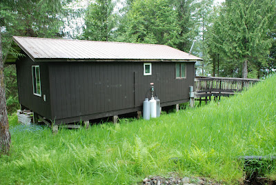
They have solar panels, propane tanks, diesel, gas, barbecues, a 4-wheeler and apparently all the amenities needed to enjoy a short stay here. When they are actively working in the area they also have trucks and other vehicles as needed.
A little way up the logging road there was a leftover pile of log scraps. These are the logs they deemed of no use. Back in the day there were extensive logging activities taking place here. Lisa and I were here once when they were logging and the big logging trucks would bring down a load of logs and dump them into the water. Then these little, but powerful, "log bronc" little tugs would push them around and form them into a raft for later towing to town.
I came across something odd attached to a tree, and it took me a few minutes to figure out what it was. Back in my younger days I was a hunter and I quickly learned it was far easier to skin and butcher a deer that was hanging as compared to doing it with the deer laying on the ground. I think this was for hanging deer.
This must be the Shoal Cove road parking lot. I suspect hunters have left vehicles here for use during the hunting season.
Before I walked up the road the guy with the small boat came back. He had a small scooter and had been looking for bear. He said he had gone about 12 miles on the road system and had seen no bears, but had seen "a lot of deer." It didn't take long on my slow walk up the road to come across this doe. I see deer quite frequently along the 3rd Ave bypass road, but there is something special about seeing them out here, far away from town, in their natural habitat. You can see why back in my younger days when I hunted we would call these does "propeller heads." In this area you can only shoot bucks and deer season opens on August 1st.
Up the road there were tons of deer tracks, but I saw no deer.
I did see evidence of either a wolf or a bear, I could not tell which.
Just across from the dock there is a very round "basin" in the beach. I have been told that it is the remains of an ancient native fish trap. In the late summer and early fall the salmon are thick around here. I guess the theory is that when the tide is high the fish mill around that area, and some of them are in that basin. As the tide falls they become trapped there and can be just scooped out easily.
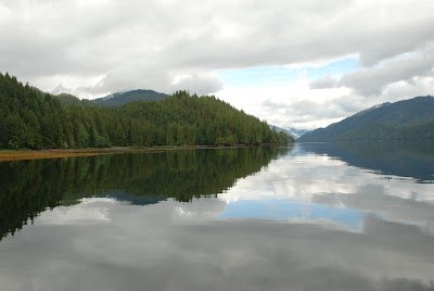
Just a couple more shots of the beauty of Carroll Inlet from this spot.
I had a quiet lunch here and then decided to head for town.
The closer I got to town the worse the weather got. When I pulled into my slip at Bar Harbor at about 4 PM it was in heavy rain and stiff SE breezes.
Total mileage this trip was about 52 nm.


No comments:
Post a Comment