The Naha has always been one of the very special places in my life. I first walked up that trail in June 1978 when I was 27 years old, and now I am 71. I don't even know how many times I have been there. It is one of the places I must visit from time to time to restore my soul.
The weather forecast for the next few days was excellent, with no rain and no wind, so I decided to make a 3 day trip out of it. I left Bar Harbor at about 6 AM and headed West. Many people in Ketchikan call that direction "North," but you don't have to be a genius to determine it is actually West. Just pay attention to where the sun sets. When you get to Clover Pass that's where you head North.
On the way out I passed the Alaska Marine Highway System ferry Hubbard sitting at the Vigor shipyard dock. This ferry was just being built when I left Ketchikan in May 2018. It was designed as a "day" boat and so did not have crew quarters. Now the ferry system has decided to use it for longer voyages and so they are having the Vigor shipyard install crew quarters. One of my son Ryan's friends works for the ferry system and arranged for me to have a full tour of the vessel, including the engine room, which was impressive.

The ferry Columbia is up on the ship left getting some work done that requires it to be out of the water. She was supposed to be in service this summer season, but the ferry system could not hire enough workers to be able to fully staff her.

I passed the Alaskan Salvor on the way out. This vessel is owned and operated by Greg Updike and his company Alaska Commercial Divers. They are workaholics I think as I see this boat out at all times of the year and in all sorts of weather. Greg usually steps out of the wheelhouse and gives me a wave when we pass each other.

You know you're old when you remember not only the previous name of an establishment, but also the previous previous name. This place used to be called "The Narrows," then it became "The Edgewater Inn," and now is called "The Ketch." They have a restaurant, a bar, and rooms to rent. I think they may also run fishing charter boats out of there. Ryan and I had dinner there a couple of weeks ago and the food was very good.

While I was out of town for 3 years living in Gig Harbor WA they built a cruise ship dock in Ward Cove. It can handle 2 ships, one on each side. I have read that they have also built several touristy type shops down there called "The Mill," (I suppose named that way because that is the former site of a pulp mill.) I have never been down there to check it out. It always amazes me to see cruise ships in that little cove. Once they get in there they have to back out because there is not enough room to turn around in there.

One my way up into Western Behm Canal I saw something I have never seen before, a cruise ship in there. This is a "closed" waterway, in that Behm Canal encircles the island that Ketchikan is on. I've never seen a large cruise ship in Behm Canal. Don't know what they were doing there this day.

On the inside of Grant Island sits Silver King Lodge. This is quite a going concern during the summer months. They close down during the winter. They have several buildings and offer lodging and fishing adventures to tourists. I know they offer small skiffs and guests take them out themselves, that is without a guide. I don't know if they also offer guided fishing charters.

On the way to the Naha you weave through and around a few small islands. These create unique little nooks or coves along the way. Inside one of these is what I call "Fader's Castle In The Woods." Many years ago, a couple Greg & Jean Fader bought this property and built what I call a castle due to the two main towers. They lived there for some time and then Greg got cancer and passed away. Jean tried to live there alone for a while, but it was just too hard, so she eventually sold the property. I don't know who owns it now. I always slow down when I pass by so my wake does not disrupt their dock.

A friend of mine, Ed Purvis, and his wife Linda bought this property which is on the way to the Naha. He called it "Freedom Point." He gave me a tour one day. It is completely off the grid, meaning that he had to provide his own electrical power, water, sewer treatment, etc. He had generators, solar power, a big shop, a big hot tub, and a great dock. He even had rigged up a pulley system to move large loads up from the dock to the front of the house. Eventually age took its toll and Ed was unable to keep up with the demands of an off-grid home, so he sold it and moved south to be closer to family. I don't know who owns it now, but each time I pass by it seems to have deteriorated a little bit more.

This is the very small village of Loring. I don't know if anyone lives here full time anymore. Loring and the Naha area used to be a very major salmon capture site. Large ships from Seattle would come up and take the loads of salmon back south. That was of course before the days of salmon conservation and preservation of the run were in place. That brown chalet style house was not there I think before I moved away in 2018.


This is the State of AK float in front of Loring. It is available on a first come first served type basis for boats to tie up. I have tied up there a few times when the Naha USFS dock was full. It is somewhat exposed to the North so if a Northerly blow comes through you can expect a rocky night there.

Right next to Loring in a little nook is a large private lodge. It was built on a 62-acre plot (which I only know because the bank I worked for financed the property). I read an article about the lodge in a real estate magazine where they described and showed photos of every room. Each room had a unique theme. The original owner had a large boat and a smaller runabout boat. Then the big D hit him - divorce, and he lost the property. I don't know who owns it now, but I do see activity there most of the time when I pass by, so it appears to be actively in use.

I got to the Naha USFS dock at about 9:15 AM. There was a boat there already, a larger boat named the Aqua Holic, but there was still room for me to tie up. The man and wife aboard the Aqua Holic came out to help me get tied up, which is always appreciated, especially since now on most of my trips I am alone. That smaller boat tied up in front of the Aqua Holic is a USFS boat. More about them later.


The couple on the Aqua Holic were very friendly and we chatted for a while on the dock. They were from the Tacoma area, which is very close to where I lived in Gig Harbor. They had never been to the Naha before so of course I had to fill them in on the area. We walked up the trail together, at least first part. They decided to continue up the trail to the Orton Ranch, while I decided to wait until after lunch to make that walk.
I think this is the same trail sign that was there when I first walked the trail in 1978. I think it's time for a replacement.

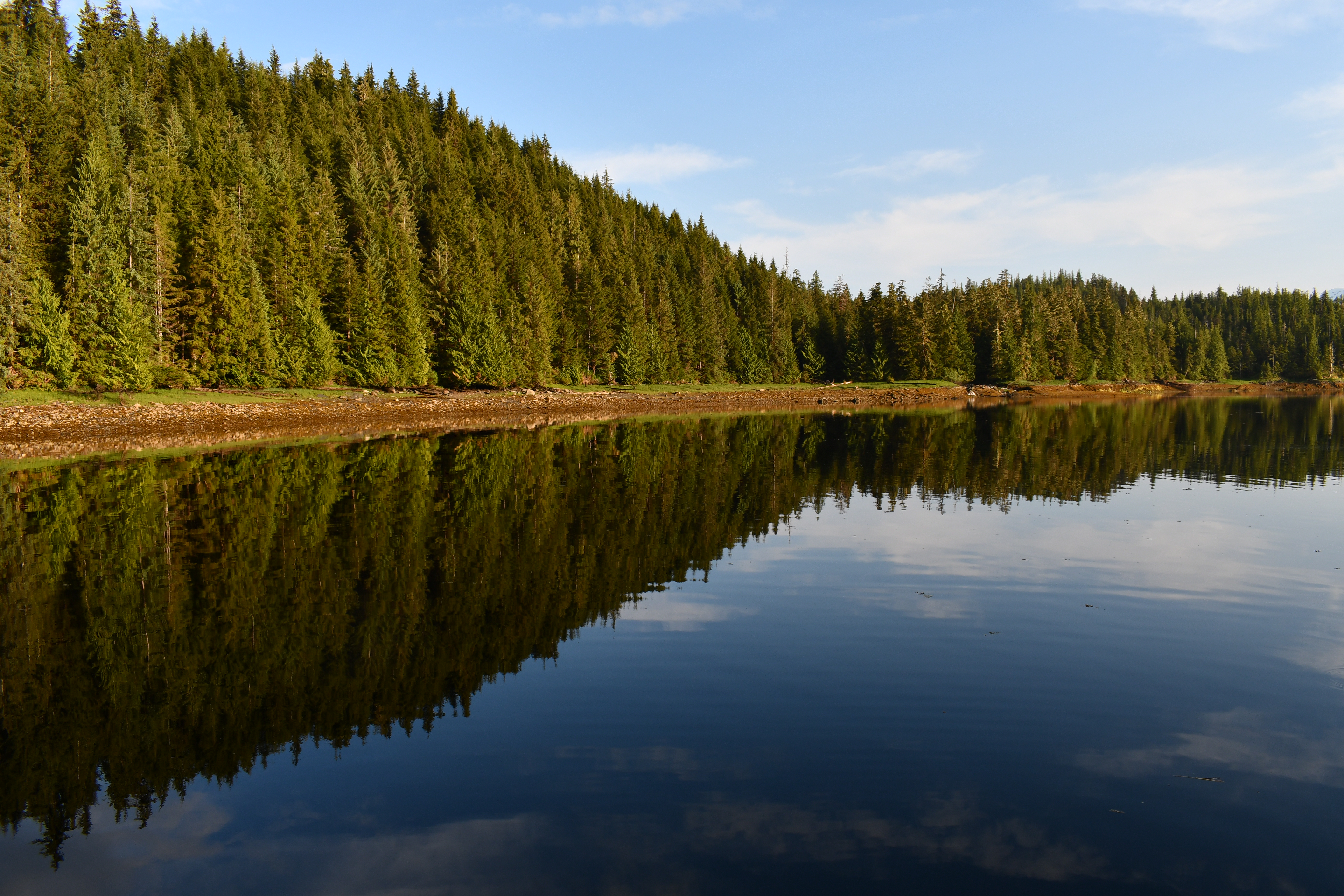
This area is called the "Naha" because it connects to the Naha River. But the river itself does not connect directly to salt water. There is a lagoon, Roosevelt Lagoon, in between. The lagoon looks like a lake but is not a lake because saltwater flows in and out depending on the state of the tide. There is a raceway, or a rapids, in between Roosevelt Lagoon and the salt water. At high tides a small skiff can be run up there to get into the lagoon, but at lower tides it is too rocky and fast moving to get a skiff through there.
I have at least dozens and possibly hundreds of photos of different areas of Roosevelt Lagoon, but I never tire of its beauty.


This is one of the permanent residents of the area I saw as I walked up the trail. Some people say these are just berries with a skin stretched over it and would make a good survival food. Personally, I think I would have a very hard time eating one of these.

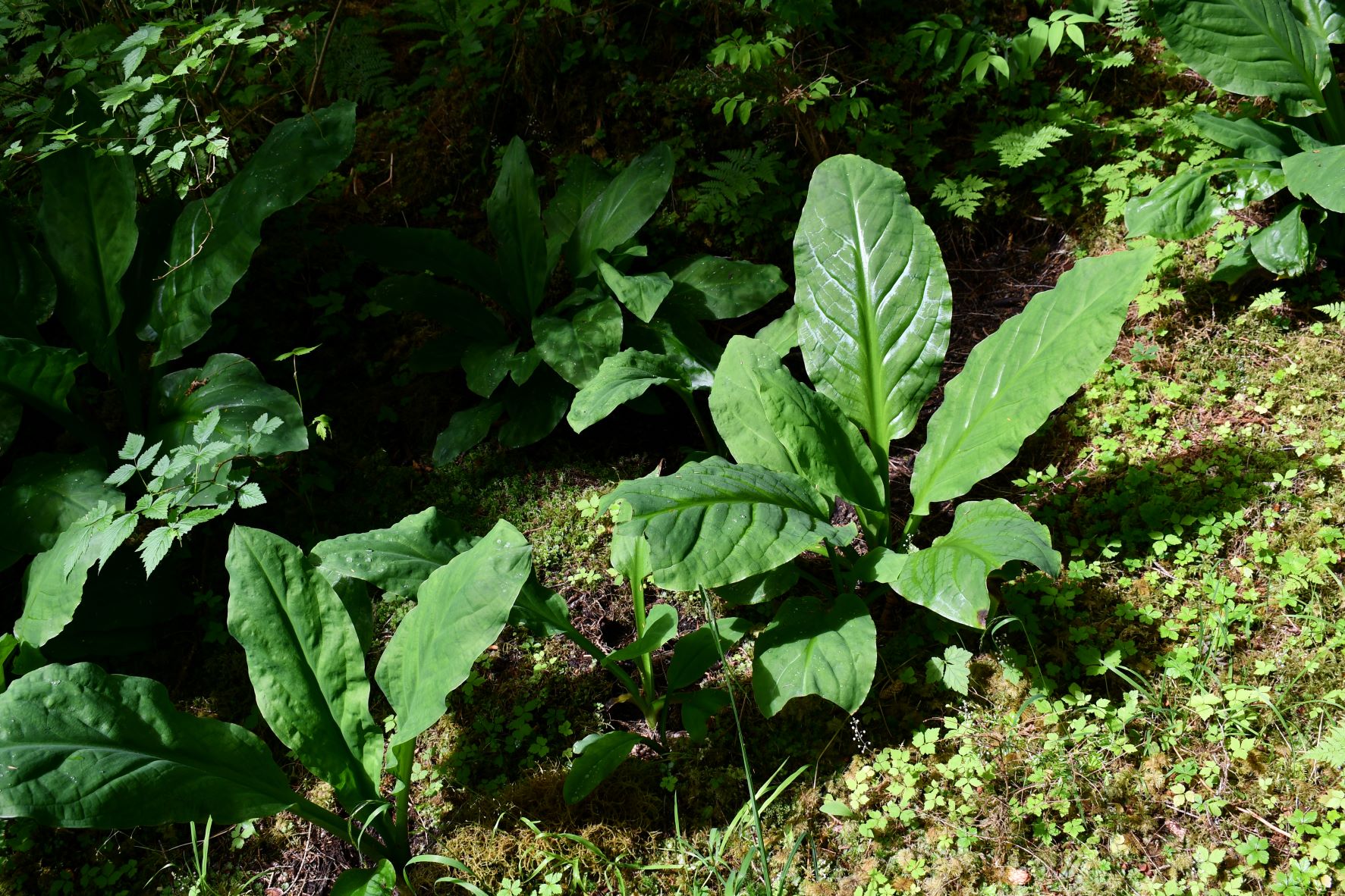
This early in the summer there are no salmon in the rivers yet, so the bears are eating other things. They dig up the skunk cabbage and eat the roots. The first photo shows an untouched skunk cabbage, and the second shows one after a bear has dug up the roots.

As I have said, I have walked this trail dozens of times. And on those walks I have seen bears many times, but always from a distance. On the walk today was the first time I came face to face with a bear on the trail. I heard a strange sound and looked up, and there was a bear halfway up a tree directly in front of me. He stopped and looked at me, and I stopped and looked at him. I had my camera around my neck, and I fired off 3 quick shots, but only one is even close to usable. I apologize for the quality of lack thereof of the shot, but I didn't have much time to shoot it.

I eventually made it up to Orton Ranch. Orton Ranch has been owned by the Baptist Church since before I came to Ketchikan in 1978. They use it for their own church retreats, but they also rent it out to other churches, Boy Scouts, Cub Scouts, Girl Scouts, and any other group that might want to use it. There are many buildings which include a care taker's cabin, main dining hall, 3 or 4 large bunk houses, a large generator shed, and a duplex looking building, as well as other small out-buildings. There was an article in the paper the day before I left for this trip announcing that KIC (Ketchikan Indian Corporation) had purchased the property. KIC has their work cut out for them as the place looked in desperate need of repair. I spent about 30 minutes here resting before heading back down the trail.
In this first shot you can see most of the buildings, but not all of them. It is a large and spread-out facility. As you can see, just keeping the grass mowed is quite an undertaking, much less maintaining all of the buildings.


This is the care taker's cabin. You can see the large radio antenna. Back in the day they used VHF radio to communicate as there is no cell service out here. I suspect in recent years they switched to some form of satellite phone for communications.

While I was resting up and preparing for the hike back to the boat the aforementioned USFS people passed by. They seemed to be using some kind of app on iPads for something as several of them were carrying iPads and referring to them frequently. They were here today not to actually work on the trail, but to scope out and assess the work that was needed on the trail.

The trail is in pretty bad shape, except for perhaps the first few hundred yards. The boardwalks are broken, slanted, and non-existent in some places. It was hard for an old man like me to get by some of the areas. Here is a shot of just one area where the boardwalk was totally broken out, and someone had placed great slabs of a tree trunk in place for you to walk over.

When I got back from my hike the people from the Aqua Holic were out on the dock in folding chairs just chilling out, so I joined them. Soon after that a 47' Canadian boat named the Over Early came in and tied up and that couple joined us on the dock as well. It was a beautiful evening, and we all enjoyed chatting about boating and all the places we have been and the experiences we have had.

These days most of us boaters rely heavily on electronic navigation devices. I know some "old school" boaters still keep paper charts on board, but I did away with them a long time ago. I have 2 Garmin navigation units, an app on my laptop that I can use for navigation, and another app on my iPad that can be used for navigation. So, I don't feel the need to keep paper charts on board. But as one who worked with computers for my entire professional career knows, computers can screw up sometime. Look at this photo of my smaller Garmin GPS chart plotter. You can see the line coming in from the left that shows my track when I came up to the dock. But then, apparently while I was sleeping, the boat took a couple of side trips without my knowledge, one of them going onto dry land. You just have to keep in mind that we cannot trust the electronics without question, because sometimes they mess up.

Apparently, I must have been the early bird of the group, because I got up about 6 AM and pulled away from the dock at about 7:30 AM, and I never saw hide nor hair of my new friends on the Aqua Holic or the Over Early.

My next destination was Yes Bay, about 20 miles to the North in Western Behm Canal. I had been in Yes Bay many times, and there are 2 good anchorage sites in the bay. The first is a little "nook" on the left side as you go in, just as you pass the lodge. I have anchored in there many times. But there is another anchorage, known as the "inner basin," further up into the bay. You have to go through a particularly "skinny" section, which is probably why I had not tried it before. But today I made my way up there and successfully negotiated the skinny section in order to reach the inner basin. No one else was there so I had it all to myself. It's a beautiful area, and a wonderful anchorage.


This was my anchor site in the inner basin at Yes Bay.

In the morning I decided against my normal breakfast of cold cereal and splurged and made pancakes. I always told the kids; I don't do survival trips.

When I fired up the engines and the electronics for the return trip the Furuno autopilot was showing an error. It has its own internal electronic compass so that it always knows which way the boat is headed and that "heading sensor" was not feeding data to the main processor for the autopilot. I pulled out the manual and all it said was to turn it off and back on again a few times and if that didn't work to call your dealer. I ran this boat for almost 10 years without an autopilot, but I sure have gotten used to having it. So, I had to manually steer the entire return trip to town, and this is now on my things to repair list.
As I exited Yes Bay in the morning, I snapped a couple of quick photos as I passed by. I didn't take any on the way in because there was a scantily clad woman sunbathing on the dock and I didn't want to appear to be ogling.


I have never been inside the lodge. If you want to read more about them you can do so at Alaska Vacation | Ketchikan, AK - Yes Bay Lodge. My new friends on the Aqua Holic told me they had dinner in there. You have no choice, it is always King Salmon for dinner, and it was $65 a plate. But they said it was very good.
I didn't want to get to town too early because I really had no reason to get back early, and also when it is hot and sunny like this there is usually a brisk late afternoon and early evening breeze. I wanted to get back a little closer to 9 PM when I hoped it would be calm.
So, I pulled into Traitors Cove, Marguerite Bay USFS dock to hang out for a few hours before heading back to town.

Yes, I know I was in the loading zone on the front of the dock where no moorage is allowed (there are signs.) But no one was around, and it was much easier to get into this spot because the wind blew me right into the dock. I was prepared to leave at a moment's notice if anyone came in and needed the loading zone.
I had the windows and the back door to the cabin open because it was so hot. While I was sitting there a couple of hummingbirds came by and hovered right by the open back door. I thought they were going to fly right into the cabin. I still have a lot to learn about my new camera, but one thing I had learned was that it has what I call "machine gun" mode, where it fires off repeatedly and rapidly as long as you hold the button down. So, I set it to that mode, and then aimed it at the back door and waited. Sure enough they came back, and I got a couple of good shots amongst the many that weren't so good.


I was just hanging out playing guitar when I saw a boat come into the bay. Not wanting to get in trouble for being in the loading zone I prepared to depart a little earlier than I had planned. The boat was named Muirgen and I could not see its hailing port. They anchored right out in front of the dock. They were just preparing the tender to run people to shore when I left.

I pulled away from the Marguerite Bay dock at about 4:30 PM and headed for town. I did not cook dinner this evening but just made a sandwich to eat while underway.
I arrived into my slip at Bar Harbor at about 8:30 PM in calm conditions without incident.
Total miles this trip was 91.8 nm.