Monday, January 16, 2023

2023-01-13 Shelter Cove Trip

 First trip of 2023, WooHoo!

I had not been out since the Naha day trip on Dec 3rd.

I went south for the holidays and was out of town for 3 weeks.  On Dec 31st there was a boat fire on the boat directly behind me.  Thankfully there was no damage to my boat, but it scary nevertheless until I got back and could check it out myself.

I am running the City League basketball program right now, and we play games on Sunday, Tuesday and Thursday and that sort of limits what days I can get out, especially if I want to stay overnight.

The weather forecast for Friday and Saturday showed rain, but little to no wind, so I scheduled an overnighter to Shelter Cove in Carroll Inlet.  It is relatively close to town, and Carroll Inlet is a beautiful area.

Many commercial fishermen have a suspicious nature and will not leave port on a Friday, much less on a Friday the 13th.  But I was not about to let that stop me.

I pulled out of my slip at 8 AM just as it was getting light.  The forecasts said nothing about fog, but fog there was, in spades!

Here is the view outside my window.  I couldn't see anything at all.


In conditions like this I have to rely solely on my equipment, primarily the GPS, AIS, and radar.  The GPS shows my location in relation to bodies of land, the AIS shows the presence of larger vessels such as tugboats, ferries, barges, and cruise ships, and the radar shows what is actually out there, most importantly other vessels that are not broadcasting an AIS signal.

My Garmin GPS chart plotter has the ability to split screens, so in conditions like this I usually have the navigational chart on one side and the radar on the other.  This is what it looks like.


The thing about radar is that it is not an exact science.  My radar set is 15 years old, and I suspect the newer versions are more accurate and faster.  The signal "sweeps" around the screen in a circle painting "blips" where it sees land or objects.  The thing is that it regular paints blips in error and they disappear in the next sweep or two.  So, when I was in close quarters making my way SE through town the radar kept showing these little blips all over the place, and then they would eventually disappear.  It makes things a little stressful because you can never really tell whether that little blip is a small boat or just a phantom blip.

On the above image of the radar, I have the range set to look out to only 1 mile, with each ring being a half-mile from the boat.  When I am out in more open waters, I increase the range so the radar can see further out.

I made it safely through the congestion of town without hitting anything, but I had to run very slowly because in dense fog like that you cannot see the logs and other debris in the water ahead of the boat.

The fog was dense all the way out to Mountain Point where it opened up briefly.  From there until I got to the Shelter Cove USFS dock the fog opened up and closed a few times.  

Carroll Inlet is a very beautiful area, and with the fog and mist rising and then dropping again it made for somewhat eerie vistas along my route.


The one thing that is nice about running in fog is that it is almost always flat calm water, and that was definitely the case on this run.


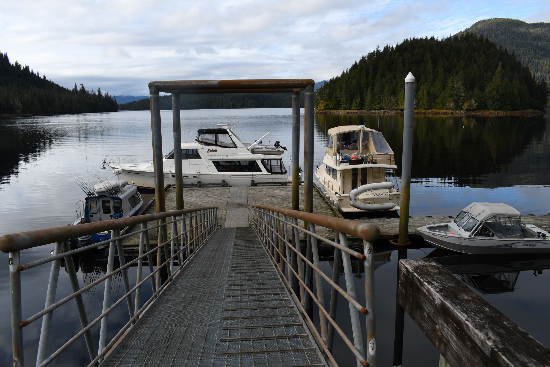
I arrived at the USFS dock at Shelter Cove at a little before noon.  It took me longer than usual to get out here because of all the times I had to slow down in the dense fog.

This area is occasionally logged and when there are loggers here the dock is inaccessible to pleasure cruisers like myself.  Sometimes they tie a huge barge to the tiny USFS dock.  I have heard there is now a road from town out to this location, although I do not know where it originates on the town side. That saddens me because one of the reasons I come here is for solitude.  In the summer I anticipate running into pickup truck loads of teenagers with weapons and fireworks.

Here's what the dock looks like as you approach it.  It is in a little nook of the shoreline, and you cannot see it until you turn that last corner.


Sometimes there are USFS vehicles parked at the top of the ramp, but none were there on this trip.

The rain was coming and going in spurts, and I took advantage of a brief lull in the rain to jump out and get a selfie of me by the boat.


After a quick lunch I geared up with warm clothes and boots and full rain gear, as by now it was raining pretty hard.  I could not use my good Nikon camera in this rain, so I took some shots with my cell phone.  I took a short hike up the logging road.

I usually carry my pistol on these hikes but when I went to unlock the trigger lock, I discovered that I had left the keys at home, so no pistol on this walk.

Right at the top of the ramp there was a large patch of glare ice, which I avoided by walking around the edges. I had some ice cleats on the boat, but I don't think they fit over my size 13 Xtra-Tuff boots.


From the logging road I got this photo of the boat at the dock.  That's solitude for you.


On the road there was light snow at first, and then it got deeper as I got further up the road.  There were tons of deer tracks and also wolf tracks, which was a little disconcerting since I did not have my pistol with me.

These are some of the deer tracks.


Here is a wolf track, one of many along the road. I should have put something down to give it some scale, but they were all quite large.


I was walking this road in January of 2014 and there was no snow on the road at that time.  As I walked along, I heard quite a commotion in the brush along the side of the road.  I remember it sounded too loud to be a deer as they are usually very furtive and almost silent when they move through the brush.  I turned to look and saw a wolf in the woods to the side of the road.  I was a little flustered at first, not knowing if I should go for my pistol or my camera first.  I opted for the camera, and this is one of the many shots I took.


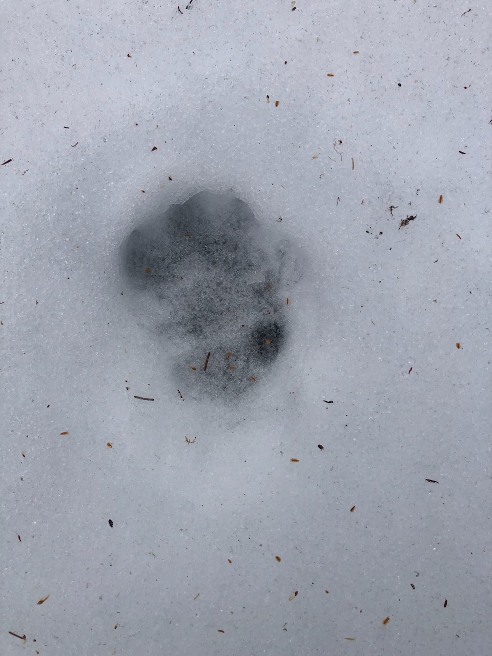
This wolf was caught in a trap, and that is why he wasn't running.  I knew there were traplines in the area as there was a sign up near the ramp.  I felt a little sorry for this guy, but there was nothing I could do for him, so I continued on my walk that day.

I walked on and on up the logging road and the snow got deeper and I started breaking through on every step.  I don't have snowshoes, but that would have been the ticket for today.  As I got up to the junction in the road I looked down at more miles of snowy road.  I cut my walk short and headed back to the boat.  This scene reminded me of guitarist Tommy Emmanuel's piece entitled "The Endless Road."


I have gotten crabs in this area in the past, usually setting pots right in front of the dock.  On this day I was a little lazy, so I set two crab pots right from the front of the dock.  There were no other boats around so that area was clear.  I use chopped up herring and parts from salmon carcasses for bait.

I let the pots sit overnight and as soon as it just getting light on Saturday morning I went out and pulled them.  In our area for Dungeness crabs they must be males and also be over 6 1/2" wide.  In my first pot I got only 1 but it was legal.


In my second pot I got 3, but one of them was way too small to keep.  I guess it wasn't actually quite light yet because even with the flash the photo came out pretty dark.  


I decided to only keep 2 of the 3 legal crabs I got because the pot I use to cook them can only handle 2 crabs at one time.  And since I am alone, 2 crabs were plenty for me.

The next task was to set up my propane crab cooker on the dock.  I have been using a stove called a Woodland Power Stove for several years now.  I like it because it folds up flat and stores in a nice canvas bag.  And it has its own hose that goes to the propane tank.


However, I quickly figured out that my stove was unusable.  The storage locker under my flybridge seat occasionally fills with rainwater because the drain hole gets plugged up with dirt.  So, the stove and much of my other gear in that locker sat in about a foot of rainwater for a long time, and the valve that controls the flow of propane was non-functional.  I'm afraid it is kaput, and it is time for a new crab cooking stove.

Plan B was to pull out my Coleman camp stove.  I have an electric stove on board, but it is really wimpy and would probably never boil the big pot of water needed to cook crabs.  The Coleman doesn't generate as many BTUs as the Woodland Power Stove, but it's much better than the stove on board.


If anyone is curious, here is how I cook my crabs.  I keep the crabs alive in a bucket until just before cooking them.  I have read that they have toxins in them and if you butcher them and let them sit for a long time you are danger of getting sick from the toxins.

I use a big pot of sea water and get it to a rolling boil.  Then I butcher and clean the crabs and drop them into the pot.  Then bring the water to a second boil, and time them for about 12 - 15 minutes.

Lunch!


I wanted to get back to the harbor before dark and so I planned to leave no later than 1 PM.  I had a bit of a scare when I went to start my engines.  They balked at starting and then my electronic engine controls flashed an error.  I had visions of calling the Coast Guard on the radio and getting them to arrange for someone to tow me in.  

I thought perhaps the problem was that my starting batteries were low, so I started the generator (which has its own dedicated starting battery) and ran the battery charger for about 20 minutes. When the generator is running it pumps about 85 amps into the batteries.  After that I started the engines with no issues and made the run to town.

I arrived into the harbor just a hair before full dark at about 4:10 PM.

Mileage for this trip was 51.6 nm.

I'm already making plans for my next trip!


Sunday, December 4, 2022

2022-12-03 Naha Day Trip

Except for a very brief run out to get fuel on Nov 1st I had been essentially grounded for over a month.  I've had a diesel mechanic working on the cooling systems on my engines.  During the course of his work, we had to order more parts, some of which came from Yanmar's main office in Georgia, and so it took him a long time to get this work completed.

Diesel burns at about 1200 F degrees and one of the main issues with diesel engines is handling all that heat.  The engines have multiple cooling subsystems that require regular maintenance.

I had 3 primary goals for the trip today:

First, run the engines up to a relatively high RPM and check to see if they overheat.  

Second, pump the sewer tank, which due to the fact that I was dock bound for over a month sorely needed it.

Third, get out on the water on a clear, cold winter day.

The temperatures for the past week or so had been hovering just below 30 during the days and dropping to around 20 or so at night.  The weather forecast for this day was cold and clear, but most importantly, calm.

I pulled away from my slip in Bar Harbor North at about 7:15 AM, just as it was starting to get light.  I had my nav lights on for the first 30 - 45 minutes of the trip just to be sure.

There was a very light NW breeze blowing in the harbor and the temperature was about 21 F degrees.  Brisk!

For the past year or so I have been running the engines at only about 1800 RPM because I knew they were in need of maintenance on the cooling systems.  Today, once they were properly warmed up, I ran them up to 2000 RPM and watched the temperature gauges closely.  Both engines came up to 180 F and stayed there.  After an hour or so I bumped them up to 2200 RPM and once again they did not overheat.

I arrived at the Naha dock at about 10 AM, and just as I expected, there was no one else around.  Not many people want to come out on the water on such a cold day.

I set up the tripod and took a "selfie."


You can see the shadow of the tripod on the dock.  Looks like a skinny alien creature.

I am a firm believer that a man cannot have too many photos of his boat.


As I approached the dock area there was a bit of very light skim ice on the surface, but not thick enough to damage the boat.  There was also a lot of ice built up in between the dock and the shoreline.


I put on my ice cleats and bundled up for a short hike partway up the trail.  Long johns required.

When it gets really cold like this the ice sometimes forms little crystals that shoot up from the ground almost as if they grew like a grass.


The picnic shelter partway up the trail. Strange, no one having a picnic today.


Even though I had my ice cleats on I tried to avoid sections of the trail that looked like this.


Roosevelt Lagoon is a "lagoon" rather than a "lake" because there is a tidal rapids between the lagoon and the bay, and so when the tide is rising towards a high tide there is salt water rushing into the lagoon, making the water a mixture of fresh and salt water.  

The lagoon is mostly fresh water which makes it more likely to freeze when the temperatures get down as low as they have been.  Here are several shots of the lagoon from various angles that show the skim ice on the surface with thicker areas around the shorelines.


When there is a very light skim ice on the surface of the lagoon there is another phenomenon that occurs which, I will try to describe.  I did not have my phone with me so I could not record the audio, but from time to time the ice starts to vibrate and it sets off a sound I can only describe as a howling banshee.  It is quite eerie.  I don't know if it is triggered by a puff of wind, or a bird walking on the ice, or perhaps it is just random.  

I had a good lunch on the boat and headed back to town about 1 PM.  I timed it perfectly, getting into my slip at about 3:40 PM, just as it was getting dark.  And oh yes, I did stop briefly on the way back in and pumped that sewer tank.

41.2 nm for this trip.


Sunday, October 23, 2022

2022-10-22 Carroll Inlet Day Trip

This time of year, we get precious little good weather and so when a good weather day emerges, I like to take advantage of it if I can. The forecast showed sunny skies and very little wind on Saturday and so I decided to make a day trip out of it.  The forecast also showed a nasty storm rolling in late Saturday night and through Sunday, and so I wanted to make sure I was back safely tied up in port before that storm hit.

I fired up the engines in the dark about 6:40 AM and pulled out about 7 AM, just as it was starting to get light.  I could see well enough so that radar wasn't required.  If anyone reads these posts, which seems unlikely, they may recall that on my last outing my radar and depth finder were not functional.  I had a Garmin technician come by and of course they both worked perfectly when he was on board.

Here is my route for the day.  This is a screen shot from my Garmin InReach Explorer.  It sends a waypoint every 10 minutes while I am underway, and anyone who knows the link can go to it and see exactly where I am, within 10 minutes.  This view is zoomed down so that it will fit into one screen.  It may look like I traveled over land at times, but that is just due to the 10-minute waypoint interval.  The link to track my progress is   https://share.garmin.com/EricYoungblood  

If you go to that link, you may have to filter it for a specific time frame, or it will show you all the trips I have ever taken, which would be somewhat overwhelming.

My destination was a small unnamed cove in Carroll Inlet that has a mooring buoy in it.

You can see that it is relatively close to town, only about 18 nautical miles distant.  The red marker indicates my starting point at Bar Harbor.


I arrived at the cove at about 9:30 AM.  The weather was sunny, warm and calm.  I got tied up to the mooring buoy without incident.  Here is a shot of my GPS chart plotter that shows my position in the cove.


There's not much to tell for this trip.  I just tied onto the buoy and hung out for a few hours, mostly eating lunch and reading.  Here are some shots I took of the area around the cove.  Not a bad place to spend part of a sunny Saturday.  Note the snow on the mountain tops.  Time to get the snow tires on the truck.


I wanted to be certain to get back to town before the storm hit so I untied from the mooring buoy at 1 PM and headed home.  Sometimes the weather forecasts are not quite spot on, and I was concerned that the storm would arrive early.

I got into my slip safely without incident at about 3:30 PM.  As it turns out I could have stayed a couple more hours because it was calm right up through the evening.  As I write this entry now on Sunday morning the boat is cavorting around in the slip, and it is blowing a gale.  Glad I got back in safely.

I only logged about 36 nm for this trip.  


Monday, October 17, 2022

2022-10-15 Marguerite Bay Trip

It had been a couple of weeks since I'd been able to get the boat out for a spin, so I was getting the urge to get out of the harbor if even for just a brief trip.  One of the many advantages of being retired is being able to pick your weather for a trip.  When I was working it was either weekends or holidays or vacation time, and you just had to take the weather you were dealt.  But now I sit in the harbor and watch the weather forecasts closely.  If what I call the "regular" weather and the marine weather line up for a day or two I try to get out if I have no commitments in town to keep me in port.

One of my favorite destinations is Marguerite Bay, which is in Traitors Cove in Western Behm Canal.  There is a USFS dock there and it only about 26 miles from town.  I usually avoid going there from the 4th of July until the end of September because there is a bear and fish viewing platform there and during that time period, they fly tourists out there and drive them up the logging road in vans to go down to the platform and see the bears and the fish.  The float plane pilots tend to get possessive over the dock.  I even had one of them tell me the dock was built there for their use and that they have priority access to the dock.  I knew that wasn't true, but I went to the USFS office and spoke to the staff there.  They confirmed that the USFS people have priority access but after that it is first come first served for anyone.

I pulled out of Bar Harbor a little after 7 AM, just as it was getting light.  There was light rain falling but that quickly ceased, and I had no rain for the rest of the trip.

There was some fog floating around and I went to turn on my radar only to find it nonoperational.  I also then noticed I was not getting any depth reading from my Garmin GPS chart plotter.  The lack of radar was a concern because the fog was getting thicker the further I went.  Lack of depth finder was not as much of a concern as I was travelling a well-known route and had no plans to venture into shallow water.  But certainly, this had to be addressed as soon as I got back to town.

I have a smaller Garmin GPS chart plotter at the lower helm that is totally independent.  It was working fine however it does not have a radar component.

This is what a fog bank looks as you approach it from the water.  It looks like a white blanket that someone has draped over the water.


I run pretty slowly, usually about 8 knots, depending on prevailing current, so it took almost 4 hours to get out there.  During that time the fog lifted and dropped a few times, and I had to slow down at times in order to make sure I could see the crab and shrimp pots buoys that are prevalent in Clover Pass.

I turned into Traitors Cove and made my way up to the point where you can see the USFS dock in Marguerite Bay.  I could tell even without binoculars that the dock was plugged with boats, which surprised me.  But it is hunting season and a good weather weekend to boot, so I suspected most of those boats were people hunting.

About that same time, I noticed a very small buck with teeny-tiny antlers (spikes we call them) swimming across in front of the boat.  


Here's a shot of the dock from pretty far out.


Since the dock was plugged, I went over to the side near where Margaret Creek dumps out into the salt water.  There is a large area of shallows there that is a good spot to anchor.  I dropped my anchor there at about 11 AM.

One of the draws to this area is its scenic beauty.  I know that phrase gets overused and becomes a little diluted, but I think the scenery and views from inside this cove are unique and worth photographing.  Here are a few shots I took during the short time I was on the anchor.


Since I had skipped breakfast, I was ready for an early lunch.  About noon after I had finished lunch, I started to drop the raft down so I could go ashore and take a hike up the logging road.  It takes about 45 minutes to get the raft in the water and ready to go.  But before I could do much, I noticed 2 boats leaving the dock.  So, I pulled my anchor and moved and found a spot at the dock to tie up.  


The big boat in front is a 47' Bayliner named the Selah, home ported in Ketchikan.  There are 2 big signs on the front side of the dock stating that it is for loading and unloading only, and there is no moorage there.  I guess the people on Selah felt the rules do not apply to them.  More likely they just figured that if someone asked them to move, they would.  

A little before 1 PM I got my gear ready for a hike up the road.  I always try to be prepared for hikes like this.  I loaded my pistol and got spare ammo ready.  This is mostly for bear protection as there are many bears in the area. I have never had an issue with them, but it is better to be prepared.  I packed my Garmin InReach Explorer satellite communication device and a small handheld VHF radio.  If I had an injury or a medical emergency of some sort it would be good to be able to call someone for help.  A bottle of Gatorade, my camera, my hiking staff and I'm ready to go.

This is the sign at start of the logging road.


This is the US Forest Service cabin that is just a little way up the road from the dock.  I assume they have USFS people stay here when they have work to do in the area. Not as spacious or plush as the accommodations at Shoal Cove but it looks very comfortable.  They have a big generator and a large fuel tank, some solar power, and of course, a 4-wheeler for running around the logging road system.  If they have a lot of work to do, they will bring trucks out via barge.


About a half mile up the road from the cabin there is a fairly large stream coming off the hillside, so the USFS has a freshwater collection system there.  Amazingly there is a hose running all the way from the stream back to the cabin, a very long way.


About a mile or so up the road there is a cutoff that goes down to the bear and fish viewing platform.  Of course, I knew that this late in the season there would be neither bears nor fish there, but I walked down there anyway, just to get some photos.  It is a nice trail down off the logging road that takes about 10 minutes to walk down to get to the viewing platform.


During the peak of the bear viewing season, they have large, camouflaged panels that hide the people on the platform from the bears a little better.  After the bears and fish are gone, they take the panels down for the winter.


This is the plaque that is at the platform, memorializing when it was built and who was involved in the project.


Right at this site in the creek there is a little waterfall which makes it difficult if not impossible for the salmon the traverse, so the USFS and the Dept of Fish & Game have constructed what they call a fish ladder which allows the fish a way to get around the obstruction.  You can see parts of the fish ladder hidden by the brush near the bottom of the photo.  And yes, the fish eventually find it and make their way up it.


Up on the logging road they have an outhouse, presumably only for the tourists because every time I have come by it is locked.


During the hunting season people frequently stash 4-wheelers, motorcycles, and sometimes even trucks, in the brush for use when they come to the area to hunt.


About a mile and a half up from the dock there is Margaret Lake, and a bridge that crosses the logging road.  It affords a beautiful (there's that word again) view of the lake from its outlet into Margaret Creek.  I think this is one of the most beautiful spots in SE Alaska and even though I probably have dozens of photos from this very spot I continue to take more whenever I come here.


I got back to the boat at the dock at about 3:15 PM.  There was a mist forming over some of the waters of the cove.  I couldn't resist just a few more scenic photos of the area as seen from the dock.


The big 47' Bayliner people had 3 motorcycles from which they were hunting the road system.  Unfortunately, I left before they did so I didn't get to see how and where they loaded these bikes on the boat.


In the evening just before dark another 47' Bayliner named the Willow, homeport Ketchikan, came in and tied up to the mooring buoy which is nearby to the dock.  The mist in the area created an interesting view of the boat.  The people from the Willow came in near the dock in their skiff and were chatting with the owner of the Selah about the tips and tricks for owning and operating the 47' Bayliner.


When I got up in the morning, I saw that the spiders had been quite busy spinning webs along the ramp that goes to shore.  I wonder if they fight over who gets the best spots.


I usually have cold cereal for breakfast, but this morning I splurged and made some pancakes.  I apologize in advance for once again waxing philosophical.  While I enjoy coming to remote spots like this and enjoying the scenic beauty they offer, it also at the same times makes me sad to have to come alone.  My wife has left, deciding that she no longer wants to live in Alaska.  My 2 daughters live far away, and most of the time I make these trips alone now.  Making pancakes like this brings to mind all the countless times I've made batches of pancakes for hungry kids and grandkids.  I miss having family around.


One last photo before heading back to town.


The weather forecast called for this good weather to end Sunday evening, so I wanted to get back to town fairly early in the day.  I pulled out about 9:30 AM.  I was concerned about the fog.  There were several crab pots set in the bay and at times I could not easily see them.

But I made my way slowly out of the bay and into Western Behm Canal with no issues.  The fog was thick for about an hour, and I had no radar, so I went very slowly, watching carefully for other vessels and pot buoys.

Once the fog cleared it was an uneventful but enjoyable ride back to town.  I got back into my slip in Bar Harbor at about 1:30 PM, logging about 54 nm for this trip.